On Wednesday and Thursday, Mississippi State and Starkville braced for the wrath of Tropical Storm Isidore. Tropical Storm Isidore made landfall in the early morning hours Thursday near the Louisiana/Mississippi border on the coast.
As Isidore pushed on to shore, the storm brought with it 65 mph winds and storm surge up to five feet in some areas. Some wave heights on the coast topped to around 20 feet or higher.
“For central Mississippi, the primary threat was the heavy rainfall,” Doug Gillham, instructor of geosciences, said. “Here in Starkville we had three inches of rain on the weekend, and as of midday on Thursday we have already had six inches from Isidore.”
Gillham said that since the ground is already saturated, additional heavy rainfall will run off rather than soak into the ground causing more flooding concerns.
Isidore first started to develop into the Carribean as a strong Category 3 hurricane. The storm made its way across Jamaica and Cuba and first made landfall across the Yucatan Peninsula with winds close to 125 mph.
“Isidore was a very powerful hurricane when it made landfall on Yucatan Peninsula,” Gillham said. “We were quite certain that it would then turn north and head toward the Central Gulf coast.”
“One question remained: where and what would the storm be after it went back over warm waters for further strengthening?”
According to Gillham, the forecast track of the storm was very accurate, but forecasting whether or not it would reintensify was very challenging.
After hours of rainfall in the New Orleans area, some interstates became impassable because of the flooding rainfall.
The flooding threat in Starkville is low. Starkville is the most elevated part of Oktibbeha county according to officials. The surrounding counties have many roads underwater.
Across MSU, some electrical and network outages were reported. Lee and McComas Halls lost power around 11 a.m. Thursday for around three hours. Internet services across campus were also disrupted.
Some reports said that MSU had canceled night classes on Thursday, however later, it was ruled a miscommunication error at local radio stations.
“MUW reported to local radio stations that Thursday night classes were cancelled,” Sammy McDavid, University Relations, said. “However the broadcast said, MSU night classes were cancelled.”
“We got a lot of phone calls from people wanting to know if this was true. Later, we called the stations and asked them to correct the problem.”
“Steve Ellis at WMSV helped with correcting this problem to make students aware that night classes were not cancelled on Thursday,” McDavid said.
With the heavy rainfall over the past two days, many people were concerned about the possibility of flooding.
“We have had close to seven inches of rain as of 2 p.m. on Thursday here at Hilbun Hall,” Gillham said. “Some outlying counties have received more, and with their poor drainage system, does not help their situation.”
“For the most part, some flooding is possible in low lying areas, along with some ponding on the roads.”
“However for the most part, Starkville and MSU are not flood proned areas.”
Some MSU students are from the Mississippi coast and had concerns about their families and houses as well.
“My parents told me that they stocked up on batteries, water and food,” Raymond Ladnier, senior and native of the Mississippi coast, said. “They also tied down any loose items and brought in the pets.”
“I wasn’t too worried about the storm,” Ladnier said. “I’ve been through numerous hurricanes and tropical storms.”
“I knew that they (my family) would be safe, I just kept in touch through the night.”
The current forecast for Isidore is to bring heavy rain from the Gulf Coast to New England and into southern Canada.
“This rain will be very welcome in this drought stricken region,” Gillham said.
MSU weather forecasters continue to look at the tropics for more development of tropical systems.
“We are watching both Hurricane Kyle and Tropical Storm Lili,” Gillham said. “Either or both could have an impact on the southeast United States during the middle to end of next week.”
According to Gillham, Lili is the most likely candidate to make it into the Gulf of Mexico, but it is still too early to forecast the track and potential landfall of the storm.
Tropical Storm Isidore drenches Mississippi
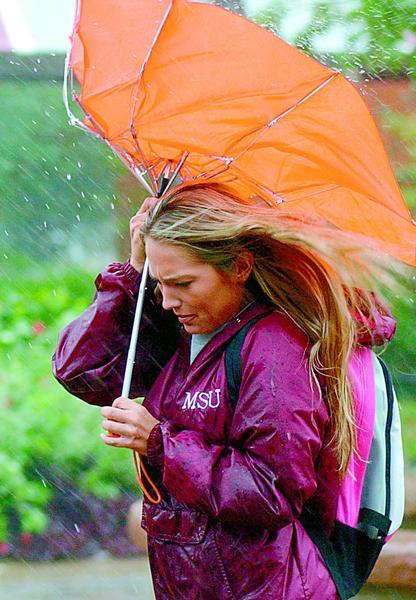
Mandi Alexander has a little trouble with her umbrella yesterday.


